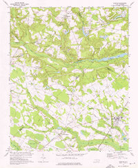
1972 Map of Parkton
USGS Topo · Published 1976About this map
Parkton and Lumber Bridge serve as the primary hubs in this agricultural and swamp-interspersed landscape of North Carolina during the early 1970s. The region is defined by a dense network of water systems, including Little Marsh Swamp and Rockfish Creek, which influenced the placement of early settlements and rail lines. The Seaboard Coast Line and the Aberdeen and Rockfish railroads provide the industrial backbone of the area, connecting small rural outposts like McNatts Sta to larger markets.
Find a feature on this map
55 named features on this map. Tap any name to fly to it.
Don’t see what you’re looking for? This feature index may not catch every label — zoom into the map to look around manually.
Map Details
Editions of this 1972 Parkton Map
2 editions found
Other maps of this area

1948 · Fayetteville
USGS Topo · 1:62,500

1948 · Clifdale
USGS Topo · 1:62,500

1948 · Nicholson Creek
USGS Topo · 1:24,000

1948 · Clifdale
USGS Topo · 1:24,000

1950 · Clifdale
USGS Topo · 1:24,000

1950 · Fayetteville
USGS Topo · 1:24,000

1950 · Nicholson Creek
USGS Topo · 1:24,000

1951 · Clifdale
USGS Topo · 1:62,500

1953 · Florence
USGS Topo · 1:250,000

1953 · Raleigh
USGS Topo · 1:250,000