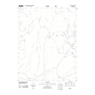
2011 Map of Parlin
USGS Topo · Published 2011About this map
Parlin serves as the focal point for this landscape in the Gunnison County highlands, where the waters of Tomichi Creek and Quartz Creek converge. The area is defined by a dense concentration of mineral extraction sites tucked into the steep drainages of Flick Gulch and Willow Creek. These operations, including the Upper Dome Mine and the Seventy-six Mine, point to a legacy of hard-rock mining that has shaped the local geography. To the south, agricultural activity persists at the Green Mesa Ranch, supported by irrigation features like the Corbitt Ditch. The map reveals a complex network of forest roads and county routes, such as County Rd-76, which provide access to the high basins and numerous mining claims that dot the drainages leading toward Indian Head.
Find a feature on this map
44 named features on this map. Tap any name to fly to it.
Don’t see what you’re looking for? This feature index may not catch every label — zoom into the map to look around manually.
Map Details
Editions of this 2011 Parlin Map
This is the sole edition of this map. No revisions or reprints were ever made.
Other maps of this area

1941 · Pitkin
USGS Topo · 1:62,500

1945 · Pitkin
USGS Topo · 1:62,500

1956 · Montrose
USGS Topo · 1:250,000

1959 · Montrose
USGS Topo · 1:250,000

1960 · Montrose
USGS Topo · 1:250,000

1962 · Doyleville
USGS Topo · 1:24,000

1962 · Iris
USGS Topo · 1:24,000

1962 · Houston Gulch
USGS Topo · 1:24,000
1964 · Signal Peak
USGS Topo · 1:24,000
1964 · Pitkin
USGS Topo · 1:24,000