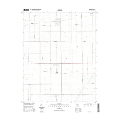
2015 Map of Parma
USGS Topo · Published 2015About this map
Parma sits at a crossroads of Missouri's agricultural heartland, characterized by a highly engineered landscape of drainage ditches and straight roads. The town is flanked by other small settlements including Risco, Tallapoosa, and Lorwood, reflecting the area's history of rural development in New Madrid County. Water management is the dominant geographic feature, with Caney Slough and man-made conduits like Ditch Number 6 and Ditch Number 1 cutting through the grid to manage the low-lying terrain. The map records several smaller nodes and points of interest for local historians, such as Forest Spur and Como, along with the Parma Cemetery and Como Cemetery. This network of roads, including State Highway UU and Mo-D, connects these communities across a landscape defined by the Public Land Survey System sections of T23N and T22N.
Find a feature on this map
54 named features on this map. Tap any name to fly to it.
Don’t see what you’re looking for? This feature index may not catch every label — zoom into the map to look around manually.
Map Details
Editions of this 2015 Parma Map
This is the sole edition of this map. No revisions or reprints were ever made.
Other maps of this area

1939 · Portageville
USGS Topo · 1:62,500

1939 · New Madrid
USGS Topo · 1:62,500

1940 · Malden
USGS Topo · 1:62,500

1940 · Pascola
USGS Topo · 1:62,500

1954 · New Madrid
USGS Topo · 1:62,500

1955 · Pascola
USGS Topo · 1:62,500

1955 · Portageville
USGS Topo · 1:62,500

1956 · Malden
USGS Topo · 1:62,500

1956 · Dyersburg
USGS Topo · 1:250,000
1971 · Catron
USGS Topo · 1:24,000