
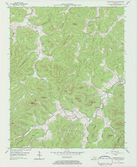
1954 Map of Parmleysville
USGS Topo · Published 1955About this map
Parmleysville and the surrounding highlands of Wayne County are captured here in the mid-1950s, a landscape shaped by narrow hollows and the meandering South Fork river. The community structure of this era is clearly visible through its distributed rural institutions, including the New Hope Ch and Big Spring Ch, along with localized education at the Huffaker Sch and Rice Hollow Sch. Much of the southern terrain is dominated by the Cumberland National Forest, characterized by prominent overlooks like Wolf Cliff and Buzzard Cliff. Extensive drilling operations are evident throughout the quadrangle, with numerous Oil Wells peppered across the ridges and along Blue Hole Hollow. This documentation of the Wayne Co and McCreary Co boundary provides a detailed view of the regional petroleum economy and the traditional hollow-based settlement patterns before modern consolidation.
Find a feature on this map
50 named features on this map. Tap any name to fly to it.
Don’t see what you’re looking for? This feature index may not catch every label — zoom into the map to look around manually.
Map Details
Editions of this 1954 Parmleysville Map
2 editions found
Other maps of this area

1911 · Monticello
USGS Topo · 1:62,500

1914 · Monticello
USGS Topo · 1:62,500

1932 · Burnside
USGS Topo · 1:62,500

1934 · Barthell
USGS Topo · 1:62,500

1934 · Pall Mall
USGS Topo · 1:62,500

1953 · Parnell
USGS Topo · 1:24,000

1953 · Monticello
USGS Topo · 1:24,000

1954 · Coopersville
USGS Topo · 1:24,000

1954 · Powersburg
USGS Topo · 1:24,000

1954 · Bell Farm
USGS Topo · 1:24,000