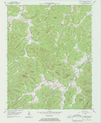
1954 Map of Parmleysville
USGS Topo · Published 1984About this map
Parmleysville and the surrounding highlands of the Cumberland National Forest define this 1954 landscape, where the Little South Fork and Beaver Creek cut through deep hollows. The settlement pattern is largely dictated by the terrain, with family-named landmarks and essential community structures like the Huffaker Sch and New Hope Ch situated along the narrow valley floors. Dozens of Oil Wells are scattered across the quadrangle, particularly near Parmleysville and in Burnett Hollow, indicating the mid-century energy production that supplemented the local agricultural economy. High elevations are marked by distinctive geological features such as Little Pilot Knob and Buzzard Cliff, while the border between Wayne Co and McCreary Co follows the ridges in the southeast, passing through Johnson Knob.
Find a feature on this map
44 named features on this map. Tap any name to fly to it.
Don’t see what you’re looking for? This feature index may not catch every label — zoom into the map to look around manually.
Map Details
Editions of this 1954 Parmleysville Map
2 editions found
Other maps of this area

1911 · Monticello
USGS Topo · 1:62,500

1914 · Monticello
USGS Topo · 1:62,500

1932 · Burnside
USGS Topo · 1:62,500

1934 · Barthell
USGS Topo · 1:62,500

1934 · Pall Mall
USGS Topo · 1:62,500

1953 · Parnell
USGS Topo · 1:24,000

1953 · Monticello
USGS Topo · 1:24,000

1954 · Parmleysville
USGS Topo · 1:24,000

1954 · Coopersville
USGS Topo · 1:24,000

1954 · Powersburg
USGS Topo · 1:24,000