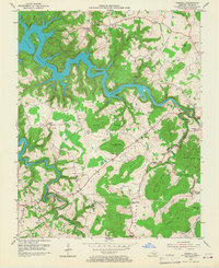
1953 Map of Parnell
USGS Topo · Published 1967About this map
Lake Cumberland dominates the northwestern corner of this Wayne County landscape, its winding fingers reaching into deep hollows like Lloyd Hollow and Eads Hollow. The 1951 aerial photography captures the region during a period of transition, where small agricultural communities and family-named landmarks are still clearly defined against the ridges. Rural life is anchored by small institutions, from Parnell Ch in the north to Shearer Valley Ch in the south, alongside local schools like Greenbrier Sch and Hall Valley Sch. Evidence of the local economy appears in the cluster of Oil Wells near Susie and the community of Oilton, marking the extraction history of the Hall Valley area. Significant elevations like Magalion Mtn and Pilot Mtn define the topography between the Beaver Creek and Otter Creek drainages.
Find a feature on this map
84 named features on this map. Tap any name to fly to it.
Don’t see what you’re looking for? This feature index may not catch every label — zoom into the map to look around manually.
Map Details
Editions of this 1953 Parnell Map
2 editions found
Other maps of this area

1911 · Monticello
USGS Topo · 1:62,500

1914 · Monticello
USGS Topo · 1:62,500

1929 · Byrdstown
USGS Topo · 1:62,500

1934 · Pall Mall
USGS Topo · 1:62,500

1953 · Parnell
USGS Topo · 1:24,000

1953 · Monticello
USGS Topo · 1:24,000

1953 · Mill Springs
USGS Topo · 1:24,000

1953 · Jamestown
USGS Topo · 1:24,000

1954 · Jabez
USGS Topo · 1:24,000

1954 · Parmleysville
USGS Topo · 1:24,000