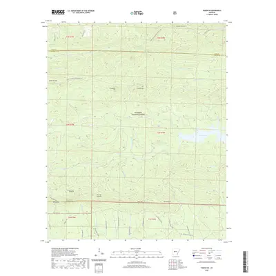
2020 Map of Paron SW
USGS Topo · Published 2020About this map
Ouachita National Forest dominates this section of the Arkansas interior, where the high ridges of the eastern Ouachita Mountains define the landscape. The geography is characterized by prominent peaks like Flatside Pinnacle, Angling Pinnacle, and Wolf Pinnacle, which overlook a network of waterways that eventually feed the Gulf Coastal Plain. Central to this topography is the Alum Fork Saline River and its reservoir, Lake Winona, which provides a significant break in the dense forest canopy. The map traces the winding route of the Ouachita National Recreation Trail as it traverses over White Oak Mtn and near Crystal Mtn, highlighting the region's importance for timber and watershed management. Dozens of service roads, including numerous Weyerhaeuser forestry routes and Lake Winona Rd, penetrate the deep drainage basins of Stillhouse Cr and Love Cr, illustrating the industrial logging infrastructure that maintains access to these steep, timbered slopes.
Find a feature on this map
51 named features on this map. Tap any name to fly to it.
Don’t see what you’re looking for? This feature index may not catch every label — zoom into the map to look around manually.
Map Details
Editions of this 2020 Paron SW Map
This is the sole edition of this map. No revisions or reprints were ever made.
Other maps of this area

1890 · Benton
USGS Topo · 1:125,000

1890 · Hot Springs
USGS Topo · 1:125,000

1894 · Hot Springs
USGS Topo · 1:125,000

1894 · Benton
USGS Topo · 1:125,000

1955 · Little Rock
USGS Topo · 1:250,000

1956 · Little Rock
USGS Topo · 1:250,000

1960 · Little Rock
USGS Topo · 1:250,000

1963 · Paron SW
USGS Topo · 1:24,000
1963 · Thornburg
USGS Topo · 1:24,000
1963 · Aplin
USGS Topo · 1:24,000