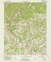
1953 Map of Parrot
USGS Topo · Published 1981About this map
The Rockcastle River and its multiple forks wind through the heart of the Daniel Boone National Forest, forming a complex drainage pattern that has historically defined movement through the region. In the early 1950s, this area of the Jackson and Laurel county border was characterized by small, ridge-top and valley-bottom communities connected by winding unimproved roads. Small rural institutions served these scattered populations, including the Seven Pines Sch and Pigeon Roost Sch, alongside family-named landmarks like the Carpenter Cem. The settlement of Parrot (Letter Box) serves as a primary reference point in a landscape otherwise dominated by intricate creek systems such as Horse Lick Creek and the South Fork Rockcastle River. The prevalence of small churches like Mt Zion Ch and Victory Ch suggests a deeply rooted local community structure within the wooded hills.
Find a feature on this map
57 named features on this map. Tap any name to fly to it.
Don’t see what you’re looking for? This feature index may not catch every label — zoom into the map to look around manually.
Map Details
Editions of this 1953 Parrot Map
3 editions found

Other maps of this area

1891 · Manchester
USGS Topo · 1:125,000

1893 · London
USGS Topo · 1:125,000

1897 · London
USGS Topo · 1:125,000

1952 · Portersburg
USGS Topo · 1:24,000

1952 · Bernstadt
USGS Topo · 1:24,000

1952 · London
USGS Topo · 1:24,000

1953 · Johnetta
USGS Topo · 1:24,000

1953 · Mc Kee
USGS Topo · 1:24,000

1953 · Sandgap
USGS Topo · 1:24,000

1953 · Livingston
USGS Topo · 1:24,000