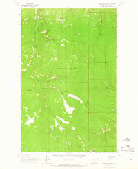
1963 Map of Parsnip Mountain
USGS Topo · Published 1966About this map
Kootenai National Forest dominates this mid-century survey of the high Lincoln County interior, centered on the towering Parsnip Mountain. The landscape is defined by its early fire-watch infrastructure and primitive access routes, most notably the Pinto Point Lookout Tower perched atop Pinto Point. This site, along with Maxine Point and Lawrence Mountain, provided the critical vantage points required for forest management before modern aerial surveillance became the standard.
Find a feature on this map
19 named features on this map. Tap any name to fly to it.
Don’t see what you’re looking for? This feature index may not catch every label — zoom into the map to look around manually.
Map Details
Editions of this 1963 Parsnip Mountain Map
2 editions found
Other maps of this area

1957 · Kalispell
USGS Topo · 1:250,000

1960 · Kalispell
USGS Topo · 1:250,000

1961 · Kalispell
USGS Topo · 1:250,000

1963 · Pink Mountain
USGS Topo · 1:24,000

1963 · Banfield Mountain
USGS Topo · 1:24,000

1963 · Webb Mountain
USGS Topo · 1:24,000

1963 · Boulder Lakes
USGS Topo · 1:24,000
1963 · Inch Mountain
USGS Topo · 1:24,000

1963 · Lost Horse Mountain
USGS Topo · 1:24,000
1963 · Gold Hill
USGS Topo · 1:24,000