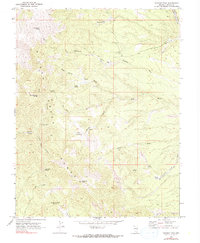
1970 Map of Parsnip Peak
USGS Topo · Published 1990About this map
Wilson Creek Range dominates this corner of Lincoln County, where the high mountain terrain is defined by a dense network of springs and dry washes. The Parsnip Peak summit rises above the surrounding landscape, providing a landmark for the network of primitive Jeep Trails that traverse the canyons. The presence of Buckhorn Ranch suggests the persistent cattle ranching heritage of eastern Nevada, relying on scattered water sources like Frenchman Spring and Lower Frenchman Spring to sustain livestock.
Find a feature on this map
27 named features on this map. Tap any name to fly to it.
Don’t see what you’re looking for? This feature index may not catch every label — zoom into the map to look around manually.
Map Details
Editions of this 1970 Parsnip Peak Map
2 editions found
Other maps of this area

1956 · Lund
USGS Topo · 1:250,000

1960 · Lund
USGS Topo · 1:250,000
1970 · Mt. Wilson SW
USGS Topo · 1:24,000
1970 · Mt. Wilson
USGS Topo · 1:24,000

1970 · Pierson Summit
USGS Topo · 1:24,000

1970 · Parsnip Peak
USGS Topo · 1:24,000

1972 · Buck Wash Well
USGS Topo · 1:24,000
1972 · Eagle Valley Reservoir
USGS Topo · 1:24,000

1972 · Miller Canyon
USGS Topo · 1:24,000

1973 · Schoolmarm Basin
USGS Topo · 1:24,000