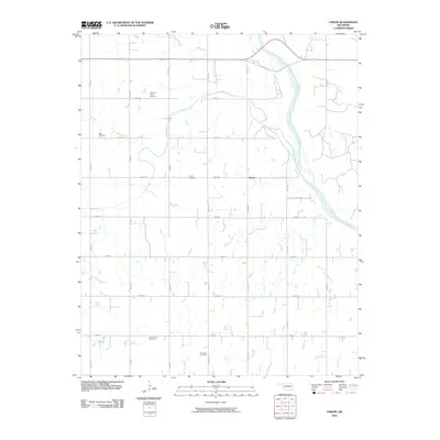
2010 Map of Parvin
USGS Topo · Published 2010About this map
The Cimarron River winds through this central Oklahoma landscape, defining the northeast corner of a region dominated by a precise grid of section line roads. In the early 21st century, the small settlement of Parvin serves as the focal point for a surrounding agricultural community that relies on the drainage of Salt Creek, Spring Creek, and Squaw Creek. This map is particularly significant for genealogical research, as it identifies several small, family-named burial grounds tucked away in the sections. These include the Holcomb-Cook Cemetery and Todd Cemetery in the northwest, alongside East Cooper Cemetery and Immanuel Cemetery to the south. The distribution of these sites across the section grid reflects the deep-rooted settlement patterns of the local farming families who established these private and community plots throughout Kingfisher County.
Find a feature on this map
26 named features on this map. Tap any name to fly to it.
Don’t see what you’re looking for? This feature index may not catch every label — zoom into the map to look around manually.
Map Details
Editions of this 2010 Parvin Map
This is the sole edition of this map. No revisions or reprints were ever made.
Other maps of this area

1893 · Loyal
USGS Topo · 1:62,500

1893 · Ames
USGS Topo · 1:62,500

1955 · Clinton
USGS Topo · 1:250,000

1955 · Woodward
USGS Topo · 1:250,000

1956 · Ames
USGS Topo · 1:62,500

1957 · Clinton
USGS Topo · 1:250,000

1958 · Woodward
USGS Topo · 1:250,000
1972 · Loyal NW
USGS Topo · 1:24,000
1972 · Loyal
USGS Topo · 1:24,000

1972 · Okeene
USGS Topo · 1:24,000