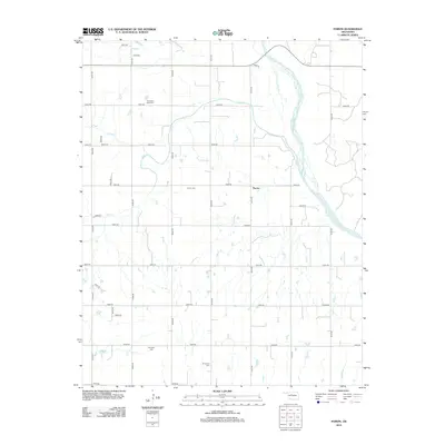
2012 Map of Parvin
USGS Topo · Published 2012About this map
The braided channels of the Cimarron River dominate the eastern landscape of this Kingfisher County region, where the prairie is carved by drainage systems like Salt Cr, Pepper Cr, and Spring Cr. This area is characterized by a high density of small family and community burial grounds, providing a clear map for genealogists. The settlement of Parvin sits centrally, supported by an extensive grid of section-line roads such as N2700 Rd and E0650 Rd. Among the most notable landmarks for local historians are the Parvin Cem, Holcomb Cook Cem, and Todd Cem, which stand alongside the Immanuel Cem and E Cooper Cem. The presence of Lease Rd near the river suggests local infrastructure dedicated to land use or resource access in this rural Oklahoma corridor.
Find a feature on this map
33 named features on this map. Tap any name to fly to it.
Don’t see what you’re looking for? This feature index may not catch every label — zoom into the map to look around manually.
Map Details
Editions of this 2012 Parvin Map
This is the sole edition of this map. No revisions or reprints were ever made.
Other maps of this area

1893 · Loyal
USGS Topo · 1:62,500

1893 · Ames
USGS Topo · 1:62,500

1955 · Clinton
USGS Topo · 1:250,000

1955 · Woodward
USGS Topo · 1:250,000

1956 · Ames
USGS Topo · 1:62,500

1957 · Clinton
USGS Topo · 1:250,000

1958 · Woodward
USGS Topo · 1:250,000
1972 · Loyal NW
USGS Topo · 1:24,000
1972 · Loyal
USGS Topo · 1:24,000

1972 · Okeene
USGS Topo · 1:24,000