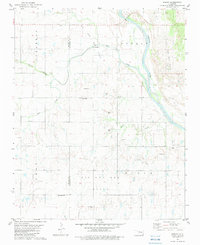
1982 Map of Parvin
USGS Topo · Published 1983About this map
The Cimarron River winds through this central Oklahoma landscape along the Blaine Co Kingfisher Co line, defining a region where river bottomlands meet active energy production. At the heart of the area is Parvin, a small settlement situated near several major watercourses, including Salt Creek, Spring Creek, and Squaw Creek. The map reveals a high concentration of resource extraction, with an extensive Oil and Gas Field covering much of the northern and southern sections. This industrial presence is contrasted by the quiet markers of local history found at Parvin Cem, East Cooper Cem, and Immanuel Cem, providing valuable location data for genealogists tracing family roots in this rural corridor. Numerous Gravel Pits dot the terrain near the river, further highlighting the region's reliance on geological resources during the late 1970s and early 1980s.
Find a feature on this map
13 named features on this map. Tap any name to fly to it.
Don’t see what you’re looking for? This feature index may not catch every label — zoom into the map to look around manually.
Map Details
Editions of this 1982 Parvin Map
This is the sole edition of this map. No revisions or reprints were ever made.
Other maps of this area

1893 · Loyal
USGS Topo · 1:62,500

1893 · Ames
USGS Topo · 1:62,500

1955 · Clinton
USGS Topo · 1:250,000

1955 · Woodward
USGS Topo · 1:250,000

1956 · Ames
USGS Topo · 1:62,500

1957 · Clinton
USGS Topo · 1:250,000

1958 · Woodward
USGS Topo · 1:250,000
1972 · Loyal NW
USGS Topo · 1:24,000
1972 · Loyal
USGS Topo · 1:24,000

1972 · Okeene
USGS Topo · 1:24,000