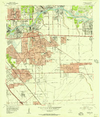
1955 Map of Pasadena
USGS Topo · Published 1957About this map
Industrial expansion along the Buffalo Bayou and the Houston Ship Channel dominates this mid-century portrait of Harris County. Large refinery complexes and filtration plants underscore the region's emergence as a global petrochemical hub, while the San Jacinto Ordnance Depot occupies the northeastern reaches. The residential growth of Pasadena is evident through a dense grid of neighborhood schools like Kruse Sch and Richey Sch, alongside the developing outskirts of South Houston and Golden Acres.
Find a feature on this map
61 named features on this map. Tap any name to fly to it.
Don’t see what you’re looking for? This feature index may not catch every label — zoom into the map to look around manually.
Map Details
Editions of this 1955 Pasadena Map
This is the sole edition of this map. No revisions or reprints were ever made.
Other maps of this area

1915 · Park Place
USGS Topo · 1:24,000

1915 · Deepwater
USGS Topo · 1:24,000

1916 · Genoa
USGS Topo · 1:24,000

1916 · Burnett Bay
USGS Topo · 1:24,000

1916 · Settegast
USGS Topo · 1:24,000

1916 · Seabrook
USGS Topo · 1:24,000

1916 · Fauna
USGS Topo · 1:24,000

1916 · La Porte
USGS Topo · 1:24,000

1919 · Deepwater
USGS Topo · 1:31,680

1920 · Seabrook
USGS Topo · 1:31,680