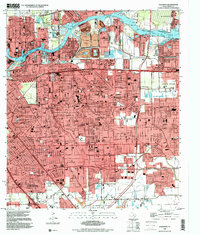
1995 Map of Pasadena
USGS Topo · Published 2000About this map
The Houston Ship Channel dominates the northern landscape of this mid-1990s survey, serving as the industrial backbone for Galena Park and Pasadena. The map reveals a densely developed suburban and industrial corridor where large-scale processing facilities, indicated by extensive tailings and the BM38 Powerplant, sit adjacent to established neighborhoods. Local life is anchored by numerous educational and religious institutions, including St Pius V Sch and San Jacinto Jr High Sch, alongside recreational hubs like Strawberry Park. The transportation network is defined by the Port Terminal RR and major thoroughfares such as Spencer Hy and Fairmont Parkway, which facilitate movement between the residential blocks of South Houston and the heavy industry lining Buffalo Bayou. This era represents a mature phase of Harris County's urban expansion, balancing community infrastructure like General Hospital with the regional demands of the maritime shipping industry.
Find a feature on this map
60 named features on this map. Tap any name to fly to it.
Don’t see what you’re looking for? This feature index may not catch every label — zoom into the map to look around manually.
Map Details
Editions of this 1995 Pasadena Map
This is the sole edition of this map. No revisions or reprints were ever made.
Other maps of this area

1915 · Park Place
USGS Topo · 1:24,000

1915 · Deepwater
USGS Topo · 1:24,000

1916 · Genoa
USGS Topo · 1:24,000

1916 · Burnett Bay
USGS Topo · 1:24,000

1916 · Settegast
USGS Topo · 1:24,000

1916 · Seabrook
USGS Topo · 1:24,000

1916 · Fauna
USGS Topo · 1:24,000

1916 · La Porte
USGS Topo · 1:24,000

1919 · Deepwater
USGS Topo · 1:31,680

1920 · Seabrook
USGS Topo · 1:31,680