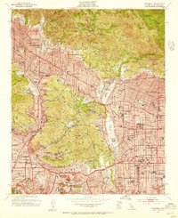
1953 Map of Pasadena
USGS Topo · Published 1955About this map
The San Gabriel Mountains rise sharply above the expanding suburbs of the Los Angeles basin in this mid-century survey. While the northern edge is dominated by the Angeles National Forest and deep canyons like Millard Canyon, the valley floor shows a densely developed grid of post-war growth. Landmarks of science and culture are prominent, including the Calif Institute of Technology and the Jet Propulsion Laboratory. The Arroyo Seco serves as a central geographical spine, home to the Rose Bowl and Brookside Park. In Pasadena and Altadena, the map reveals a sophisticated network of private academies and colleges, such as the Mt Lowe Military Academy and Occidental College, illustrating the area's established role as a center for education and research. The residential patterns of Flintridge, La CañAda, and Eagle Rock follow the contours of the San Rafael Hills, showing how topography dictated the layout of these hillside communities.
Find a feature on this map
98 named features on this map. Tap any name to fly to it.
Don’t see what you’re looking for? This feature index may not catch every label — zoom into the map to look around manually.
Map Details
Editions of this 1953 Pasadena Map
3 editions found
Other maps of this area

1894 · Los Angeles
USGS Topo · 1:62,500

1896 · Pasadena
USGS Topo · 1:62,500

1896 · Santa Monica
USGS Topo · 1:62,500

1898 · Santa Monica
USGS Topo · 1:62,500

1900 · Pasadena
USGS Topo · 1:62,500

1900 · Tujunga
USGS Topo · 1:62,500

1900 · Los Angeles
USGS Topo · 1:62,500

1900 · Fernando
USGS Topo · 1:62,500

1901 · Southern California Sheet No. 1
USGS Topo · 1:250,000

1902 · Santa Monica
USGS Topo · 1:62,500