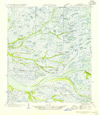
1954 Map of Pass A Loutre West
USGS Topo · Published 1954About this map
Delta Duck Club anchors a complex deltaic landscape where the Mississippi River distributaries meet the Gulf of Mexico. This mid-century survey by the U.S. Geological Survey and the Board of State Engineers reveals a labyrinth of waterways such as Main Pass and Octave Pass that defined the shifting geography of Plaquemines Parish. The map documents an intricate network of named ponds and bayous, including Major Inside Pond and John Bayou, which supported the local hunting and fishing economy of the era. The presence of features like Goose Island and Japan Island highlights the segmented nature of the marshland before late-twentieth-century coastal changes. Notable coastal landmarks such as Dead Women Bend and Twenty Seven Pass provide specific geographic points for researchers studying the historical hydrology and nomenclature of the Louisiana coast.
Find a feature on this map
109 named features on this map. Tap any name to fly to it.
Don’t see what you’re looking for? This feature index may not catch every label — zoom into the map to look around manually.
Map Details
Editions of this 1954 Pass A Loutre West Map
This is the sole edition of this map. No revisions or reprints were ever made.
Other maps of this area

1893 · East Delta
USGS Topo · 1:62,500

1893 · Forts
USGS Topo · 1:62,500

1893 · West Delta
USGS Topo · 1:62,500

1935 · Garden Island Pass
USGS Topo · 1:31,680

1935 · South Pass
USGS Topo · 1:31,680

1947 · Garden Island Pass
USGS Topo · 1:31,680

1947 · Pass A Loutre West
USGS Topo · 1:31,680

1947 · Venice
USGS Topo · 1:31,680

1947 · Southwest Pass
USGS Topo · 1:31,680

1947 · Main Pass
USGS Topo · 1:31,680