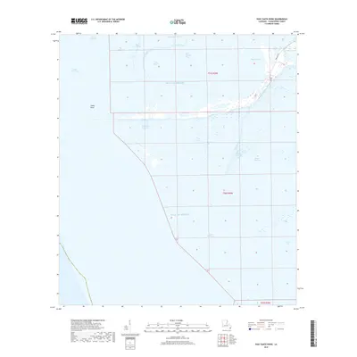
2018 Map of Pass Tante Phine
USGS Topo · Published 2018About this map
Pass Tante Phine and the intricate web of surrounding bayous define this lower Plaquemines Parish landscape as it reaches into the Gulf of Mexico. This coastal region is a labyrinth of natural and historical water routes, including the Old Spanish Pass and its more modern counterpart, Spanish Pass. The terrain is dominated by fragmented wetlands and shifting landforms like Sandy Point, where the transition from marsh to open sea is punctuated by numerous named inlets such as Bayou Jacques and Bayou Alphonse. Human presence is marked by the utilities of the oil and gas industry, visible through the inclusion of Tidewater Rd and DGS Rd, which provide access to this water-logged environment. These roads contrast with the organic shapes of Pass P'tit Francois and Red Pass, illustrating the continued effort to navigate and utilize the changing Louisiana shoreline.
Find a feature on this map
22 named features on this map. Tap any name to fly to it.
Don’t see what you’re looking for? This feature index may not catch every label — zoom into the map to look around manually.
Map Details
Editions of this 2018 Pass Tante Phine Map
This is the sole edition of this map. No revisions or reprints were ever made.
Other maps of this area

1892 · Quarantine
USGS Topo · 1:62,500

1893 · Forts
USGS Topo · 1:62,500

1893 · West Delta
USGS Topo · 1:62,500

1941 · Empire
USGS Topo · 1:62,500

1944 · Empire
USGS Topo · 1:62,500

1946 · Pass Du Bois
USGS Topo · 1:31,680

1946 · Pass Tante Phine
USGS Topo · 1:31,680

1947 · Buras
USGS Topo · 1:31,680

1947 · Venice
USGS Topo · 1:31,680

1947 · Fort St. Philip
USGS Topo · 1:31,680