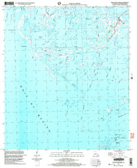
1998 Map of Pass Tante Phine
USGS Topo · Published 2004About this map
The coastal marshes and barrier environments of Plaquemines Parish define this 1998 survey, where the intricate network of the Mississippi River Delta meets the Gulf of Mexico. This landscape is characterized by a high degree of industrial integration, with numerous Oil Wells, pipelines, and an extensive Oil Field cutting through the wetlands. The map highlights the reliance on waterborne transport in this region, featuring the Venice Canal, Pass Tante Phine, and a Seaplane Ramp near West Bay.
Find a feature on this map
37 named features on this map. Tap any name to fly to it.
Don’t see what you’re looking for? This feature index may not catch every label — zoom into the map to look around manually.
Map Details
Editions of this 1998 Pass Tante Phine Map
This is the sole edition of this map. No revisions or reprints were ever made.
Other maps of this area

1892 · Quarantine
USGS Topo · 1:62,500

1893 · Forts
USGS Topo · 1:62,500

1893 · West Delta
USGS Topo · 1:62,500

1941 · Empire
USGS Topo · 1:62,500

1944 · Empire
USGS Topo · 1:62,500

1946 · Pass Du Bois
USGS Topo · 1:31,680

1946 · Pass Tante Phine
USGS Topo · 1:31,680

1947 · Buras
USGS Topo · 1:31,680

1947 · Venice
USGS Topo · 1:31,680

1947 · Fort St. Philip
USGS Topo · 1:31,680