
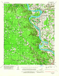
1932 Map of Pastoria
USGS Topo · Published 1965About this map
Haywood College and College Park anchor the southern landscape of this 1930s Arkansas river valley survey. The Arkansas River dominates the terrain, creating complex oxbows and reaches such as Brodie Bend and McFadden Reach. This era shows a densely settled agricultural and institutional corridor, evidenced by the large State Penal Farm and a network of schools including Jessie R Core Sch and Whitehall Sch.
Find a feature on this map
88 named features on this map. Tap any name to fly to it.
Don’t see what you’re looking for? This feature index may not catch every label — zoom into the map to look around manually.
Map Details
Editions of this 1932 Pastoria Map
2 editions found
Other maps of this area

1891 · Little Rock
USGS Topo · 1:125,000

1893 · Little Rock
USGS Topo · 1:125,000

1935 · Alexander
USGS Topo · 1:48,000

1935 · Altheimer
USGS Topo · 1:62,500

1935 · Pastoria
USGS Topo · 1:62,500

1935 · Noble Lake
USGS Topo · 1:62,500

1937 · England
USGS Topo · 1:48,000

1939 · Keo
USGS Topo · 1:31,680

1940 · Woodson
USGS Topo · 1:31,680

1941 · Alexander
USGS Topo · 1:62,500