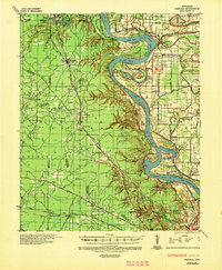
1935 Map of Pastoria
USGS Topo · Published 1947About this map
The Arkansas River dominates this mid-1930s landscape, its serpentine path defining the borders between Pulaski, Lonoke, Grant, and Jefferson counties. This era reveals a river system in transition, marked by prominent meanderings like Brodie Bend and Pastoria Bend, alongside older water features such as Old River and Silers Chute. The survey documents the river's historic migration by plotting the Meander Line 1825 against its 20th-century course.
Find a feature on this map
92 named features on this map. Tap any name to fly to it.
Don’t see what you’re looking for? This feature index may not catch every label — zoom into the map to look around manually.
Map Details
Editions of this 1935 Pastoria Map
2 editions found
Other maps of this area

1891 · Little Rock
USGS Topo · 1:125,000

1893 · Little Rock
USGS Topo · 1:125,000

1932 · Pastoria
USGS Topo · 1:62,500

1935 · Alexander
USGS Topo · 1:48,000

1935 · Altheimer
USGS Topo · 1:62,500

1935 · Pastoria
USGS Topo · 1:62,500

1935 · Noble Lake
USGS Topo · 1:62,500

1937 · England
USGS Topo · 1:48,000

1939 · Keo
USGS Topo · 1:31,680

1940 · Woodson
USGS Topo · 1:31,680