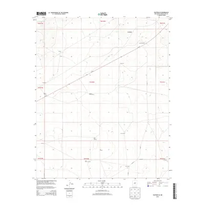
2013 Map of Pastura SE
USGS Topo · Published 2013About this map
Arabella and the neighboring settlements of Gallegos and Chaves anchor this high-desert landscape in Guadalupe County, captured just after the first decade of the 21st century. The terrain is characterized by a reliance on widely dispersed water sources, evidenced by a dense network of family and locally named landmarks like Arabella Windmill, Hobo John Windmill, and Martinez Camp Windmill. This distribution reflects a enduring ranching economy where infrastructure is dictated by the availability of groundwater across the plains.
Find a feature on this map
27 named features on this map. Tap any name to fly to it.
Don’t see what you’re looking for? This feature index may not catch every label — zoom into the map to look around manually.
Map Details
Editions of this 2013 Pastura SE Map
This is the sole edition of this map. No revisions or reprints were ever made.
Other maps of this area

1954 · Fort Sumner
USGS Topo · 1:250,000

1958 · Fort Sumner
USGS Topo · 1:250,000

1963 · Santa Rosa
USGS Topo · 1:24,000

1963 · Puerto Creek
USGS Topo · 1:24,000

1966 · Borica
USGS Topo · 1:24,000
1978 · San Ignacio
USGS Topo · 1:24,000
1978 · Pastura NE
USGS Topo · 1:24,000

1978 · Laguna De Los Terreros
USGS Topo · 1:24,000
1978 · Pastura
USGS Topo · 1:24,000

1978 · El Morro Ranch NW
USGS Topo · 1:24,000