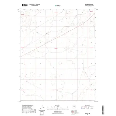
2020 Map of Pastura SE
USGS Topo · Published 2020About this map
Arabella occupies a remote high-desert position in this 2020 topographic survey of Guadalupe County. The landscape is defined by the ephemeral drainage of Arroyo El Ojito and a series of winding rural tracks that trace the township and range lines. These routes, including Gonzales Rd and Arabella Rd, represent the primary infrastructure connecting dispersed ranchlands across the rugged terrain of eastern New Mexico. The map provides a contemporary look at land partitioning within Township 8 North and surrounding ranges, where the network of county roads like Co Rd 3 D and Co Rd 3 E serves as the only link between isolated settlements and the broader regional landscape.
Find a feature on this map
17 named features on this map. Tap any name to fly to it.
Don’t see what you’re looking for? This feature index may not catch every label — zoom into the map to look around manually.
Map Details
Editions of this 2020 Pastura SE Map
This is the sole edition of this map. No revisions or reprints were ever made.
Other maps of this area

1954 · Fort Sumner
USGS Topo · 1:250,000

1958 · Fort Sumner
USGS Topo · 1:250,000

1963 · Santa Rosa
USGS Topo · 1:24,000

1963 · Puerto Creek
USGS Topo · 1:24,000

1966 · Borica
USGS Topo · 1:24,000
1978 · San Ignacio
USGS Topo · 1:24,000
1978 · Pastura NE
USGS Topo · 1:24,000

1978 · Laguna De Los Terreros
USGS Topo · 1:24,000
1978 · Pastura
USGS Topo · 1:24,000

1978 · El Morro Ranch NW
USGS Topo · 1:24,000