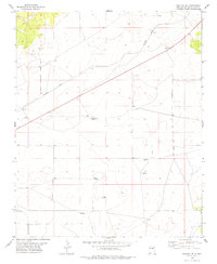
1978 Map of Pastura SE
USGS Topo · Published 1979About this map
Guadalupe Mine sits in the northwest corner of this high plains landscape, representing the industrial activity that peppered this part of Guadalupe County in the late 1970s. The Southern Pacific railroad cuts a sharp diagonal across the terrain, serving as the primary infrastructure artery for the small settlement at Arabella. This arid region is defined by its reliance on groundwater, evidenced by a dense network of named water sources such as the Arabella Windmill, Little Hamilton Windmill, and Martinez Camp Windmill. These features, alongside Histon Ranch, illustrate a pattern of scattered ranching outposts and specialized camps. The land is carved by natural drainage like Arroyo Ojito, while additional landmarks including Kist Windmill and the Hebo John Windmill provide specific geographic points of interest for those tracing the history of local land use and infrastructure.
Find a feature on this map
14 named features on this map. Tap any name to fly to it.
Don’t see what you’re looking for? This feature index may not catch every label — zoom into the map to look around manually.
Map Details
Editions of this 1978 Pastura SE Map
This is the sole edition of this map. No revisions or reprints were ever made.
Other maps of this area

1954 · Fort Sumner
USGS Topo · 1:250,000

1958 · Fort Sumner
USGS Topo · 1:250,000

1963 · Santa Rosa
USGS Topo · 1:24,000

1963 · Puerto Creek
USGS Topo · 1:24,000

1966 · Borica
USGS Topo · 1:24,000
1978 · San Ignacio
USGS Topo · 1:24,000
1978 · Pastura NE
USGS Topo · 1:24,000

1978 · Laguna De Los Terreros
USGS Topo · 1:24,000
1978 · Pastura
USGS Topo · 1:24,000

1978 · El Morro Ranch NW
USGS Topo · 1:24,000