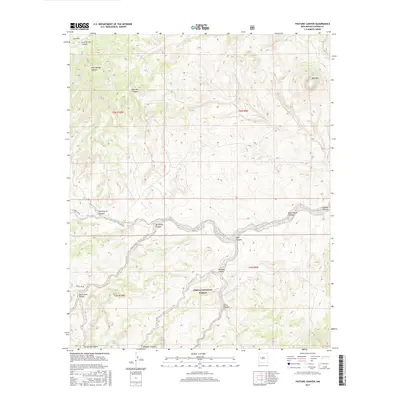
2017 Map of Pasture Canyon
USGS Topo · Published 2017About this map
Cibola National Forest encompasses much of this high-altitude landscape in Catron County, defined by a complex drainage system that feeds into the Rio Salado. The terrain is deeply incised by numerous named corridors, including Pasture Canyon and Ox Spring Canyon, which dictate the natural movement across this section of the New Mexico interior. Alamoita Creek winds through the central portion of the map, flanked by prominent features such as Bell Mtn and the cattle-grazing grounds of Cow Flat. Forest infrastructure is visible through designated routes like Forest Rd 6A, providing access to isolated water sources like Alkali Tank. The network of canyons—from Remuda Canyon to Rock House Canyon—reflects a landscape where water management and topography have historically shaped land use and forest service management.
Find a feature on this map
23 named features on this map. Tap any name to fly to it.
Don’t see what you’re looking for? This feature index may not catch every label — zoom into the map to look around manually.
Map Details
Editions of this 2017 Pasture Canyon Map
This is the sole edition of this map. No revisions or reprints were ever made.
Other maps of this area

1917 · Broom Mountain
USGS Topo · 1:125,000

1954 · Socorro
USGS Topo · 1:250,000

1958 · Socorro
USGS Topo · 1:250,000

1962 · Socorro
USGS Topo · 1:250,000

1963 · Cal Ship Mesa
USGS Topo · 1:24,000

1964 · Third Canyon
USGS Topo · 1:24,000

1964 · Wiley Mesa
USGS Topo · 1:24,000

1964 · Dog Springs
USGS Topo · 1:24,000
1964 · Bonine Canyon
USGS Topo · 1:24,000

1964 · Pasture Canyon
USGS Topo · 1:24,000