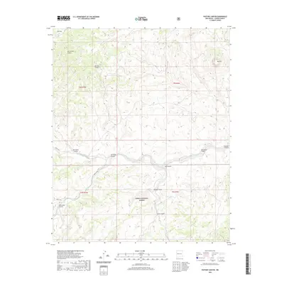
2020 Map of Pasture Canyon
USGS Topo · Published 2020About this map
Cibola National Forest encompasses the southern half of this landscape, where the high desert terrain is carved by a complex network of drainage systems. The northern portion is defined by prominent elevations such as Bell Mtn and the broad reach of Cow Flat. Water management in this arid environment is evidenced by Alkali Tank, while the natural hydrology is dominated by the Rio Salado in the northwest and Alamosita Creek, which winds through the center of the quadrangle. The map reveals a series of named canyons, including Rock House Canyon, Ox Spring Canyon, and Harrington Canyon, which likely provided natural corridors for movement and seasonal grazing. Access into these canyons is facilitated by Forest Rd 6A and Forest Rd 6B, illustrating the modern intersection of recreational and land-management infrastructure within this protected wilderness area.
Find a feature on this map
22 named features on this map. Tap any name to fly to it.
Don’t see what you’re looking for? This feature index may not catch every label — zoom into the map to look around manually.
Map Details
Editions of this 2020 Pasture Canyon Map
This is the sole edition of this map. No revisions or reprints were ever made.
Other maps of this area

1917 · Broom Mountain
USGS Topo · 1:125,000

1954 · Socorro
USGS Topo · 1:250,000

1958 · Socorro
USGS Topo · 1:250,000

1962 · Socorro
USGS Topo · 1:250,000

1963 · Cal Ship Mesa
USGS Topo · 1:24,000

1964 · Third Canyon
USGS Topo · 1:24,000

1964 · Wiley Mesa
USGS Topo · 1:24,000

1964 · Dog Springs
USGS Topo · 1:24,000
1964 · Bonine Canyon
USGS Topo · 1:24,000

1964 · Pasture Canyon
USGS Topo · 1:24,000