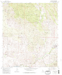
1981 Map of Patagonia
USGS Topo · Published 1986About this map
Mining operations and cattle ranching define the landscape of the Santa Rita Mountains as seen in this 1981 record. The town of Patagonia sits along Sonoita Creek in the southeastern corner, serving as a hub for the surrounding desert canyons and rugged foothills. To the northwest, the ghost town area of Alto (Site) is surrounded by an extensive network of historic claims, including the Alto Group, Bland Mine, and Lee Shaft.
Find a feature on this map
76 named features on this map. Tap any name to fly to it.
Don’t see what you’re looking for? This feature index may not catch every label — zoom into the map to look around manually.
Map Details
Editions of this 1981 Patagonia Map
2 editions found
Other maps of this area

1904 · Patagonia
USGS Topo · 1:125,000

1905 · Patagonia
USGS Topo · 1:125,000

1905 · Nogales
USGS Topo · 1:125,000

1922 · Agus Caliente
USGS Topo · 1:62,500

1932 · Lochiel
USGS Topo · 1:62,500

1932 · Elgin
USGS Topo · 1:62,500

1933 · Calabasas
USGS Topo · 1:62,500

1940 · Elgin
USGS Topo · 1:62,500

1947 · Elgin
USGS Topo · 1:62,500

1948 · Sonoita
USGS Topo · 1:24,000