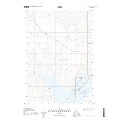
2017 Map of Patch Skin Buttes SW
USGS Topo · Published 2017About this map
Lake Oahe dominates the southern landscape of this Dewey County region, where the Missouri River's impoundment has created expansive water features like Stove Creek Bay. The terrain rises from these shores into a network of drainages including Scatter Butte Cr and Stove Cr. The settlement of Marksville sits on the eastern edge of the quadrangle, while Gray Butte serves as both a prominent topographic landmark and a named locality to the northwest. This 2017 survey illustrates the modern transportation network supporting the Cheyenne River Reservation, characterized by Bureau of Indian Affairs routes such as BIA Hwy 7 and BIA Hwy 8. The intersection of these roads and the local topography highlights the rural infrastructure of the northern plains, where ranching and tribal land management define the land use patterns.
Find a feature on this map
16 named features on this map. Tap any name to fly to it.
Don’t see what you’re looking for? This feature index may not catch every label — zoom into the map to look around manually.
Map Details
Editions of this 2017 Patch Skin Buttes SW Map
This is the sole edition of this map. No revisions or reprints were ever made.
Other maps of this area

1951 · Virginia
USGS Topo · 1:24,000

1953 · McIntosh
USGS Topo · 1:250,000

1954 · Pierre
USGS Topo · 1:250,000

1958 · Pierre
USGS Topo · 1:250,000

1958 · McIntosh
USGS Topo · 1:250,000

1969 · Artichoke Butte NW
USGS Topo · 1:24,000

1969 · Patch Skin Buttes SW
USGS Topo · 1:24,000

1969 · Four Bear Creek
USGS Topo · 1:24,000

1969 · Patch Skin Buttes SE
USGS Topo · 1:24,000

1970 · Patch Skin Buttes
USGS Topo · 1:24,000