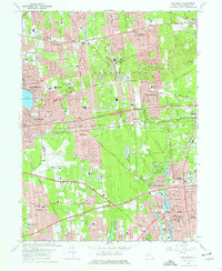
1967 Map of Patchogue
USGS Topo · Published 1977About this map
Central Suffolk County suburban expansion is in full view here during the mid-1960s, a period of rapid residential growth and infrastructure development. The landscape is defined by major transportation corridors like the Long Island Expressway and Veterans Memorial Highway, which intersect near the sprawling Long Island Mac Arthur Airport. This era saw the establishment of educational and recreational anchors, including the Suffolk County Community College campus and the Bald Hill Ski Bowl near Farmingville.
Find a feature on this map
91 named features on this map. Tap any name to fly to it.
Don’t see what you’re looking for? This feature index may not catch every label — zoom into the map to look around manually.
Map Details
Editions of this 1967 Patchogue Map
2 editions found
Other maps of this area

1902 · Setauket
USGS Topo · 1:62,500

1902 · Fire Island
USGS Topo · 1:62,500

1903 · Fire Island
USGS Topo · 1:62,500

1904 · Setauket
USGS Topo · 1:62,500

1904 · Islip
USGS Topo · 1:125,000

1904 · Moriches
USGS Topo · 1:62,500

1919 · Setauket
USGS Topo · 1:62,500

1942 · Islip
USGS Topo · 1:125,000

1944 · Bay Shore East
USGS Topo · 1:24,000
1947 · St James
USGS Topo · 1:24,000