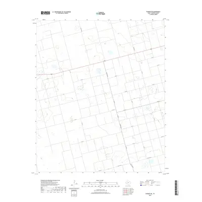
2019 Map of Patricia NE
USGS Topo · Published 2019About this map
Agricultural lands and isolated prairie depressions characterize this portion of Dawson County, where a rigid grid of local transit routes facilitates movement across the Llano Estacado. Primary east-west travel is carried by Highway 180, while a network of rural roads including Co Rd 19, Co Rd 20, and Co Rd 21 divides the landscape into expansive sections. The survey highlights the intersection of modern state-maintained routes like Ranch Rd 829 and Fm 2052 with local family-named corridors such as Stafford Rd. This layout reflects the systematic land partitioning common in West Texas, where the infrastructure is built primarily to support large-scale farming and ranching operations. Numerous small, seasonal wetlands and sinks are scattered throughout the quadrangle, illustrating the natural drainage patterns that persist despite the extensive network of graded roads.
Find a feature on this map
17 named features on this map. Tap any name to fly to it.
Don’t see what you’re looking for? This feature index may not catch every label — zoom into the map to look around manually.
Map Details
Editions of this 2019 Patricia NE Map
This is the sole edition of this map. No revisions or reprints were ever made.
Other maps of this area

1954 · Hobbs
USGS Topo · 1:250,000

1954 · Big Spring
USGS Topo · 1:250,000

1958 · Big Spring
USGS Topo · 1:250,000

1958 · Hobbs
USGS Topo · 1:250,000
1968 · Lamesa North
USGS Topo · 1:24,000
1969 · Welch SW
USGS Topo · 1:24,000
1969 · Punkin Center
USGS Topo · 1:24,000
1970 · Patricia SW
USGS Topo · 1:24,000
1970 · Patricia
USGS Topo · 1:24,000
1970 · Lamesa South
USGS Topo · 1:24,000