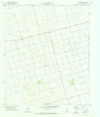
1970 Map of Patricia NE
USGS Topo · Published 1974About this map
The High Plains of Dawson County are defined here by a systematic grid of petroleum development and rural ranching during the early 1970s. The landscape is dominated by the Gin Oil Field, where a dense network of Oil Wells and a central Substa indicate the industrial footprint of the Texas oil boom. Small centers of activity such as Union and Friendship provide geographic anchors for the local community, while the presence of a Landing Strip and Radio Tower highlight the necessary infrastructure for navigating and communicating across these expansive tracts. Transportation is channeled through regional routes like 180 and 829, which pass by a designated Roadside Park. This survey captures the transition of the West Texas landscape from purely agricultural use to a vital energy-producing region, evidenced by the numerous Drill Holes and Gravel Pits scattered across the terrain.
Find a feature on this map
15 named features on this map. Tap any name to fly to it.
Don’t see what you’re looking for? This feature index may not catch every label — zoom into the map to look around manually.
Map Details
Editions of this 1970 Patricia NE Map
This is the sole edition of this map. No revisions or reprints were ever made.
Other maps of this area

1954 · Hobbs
USGS Topo · 1:250,000

1954 · Big Spring
USGS Topo · 1:250,000

1958 · Big Spring
USGS Topo · 1:250,000

1958 · Hobbs
USGS Topo · 1:250,000

1968 · Lamesa North
USGS Topo · 1:24,000

1969 · Welch SW
USGS Topo · 1:24,000

1969 · Punkin Center
USGS Topo · 1:24,000

1970 · Patricia SW
USGS Topo · 1:24,000

1970 · Patricia
USGS Topo · 1:24,000

1970 · Lamesa South
USGS Topo · 1:24,000