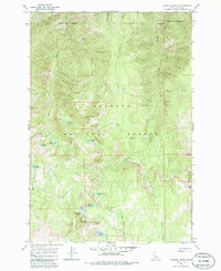
1964 Map of Patrick Butte
USGS Topo · Published 1985About this map
Payette National Forest dominates this mid-century topographic study, defined by the high-elevation peaks of the Salmon River Mountains. High points such as Patrick Butte and Sams Throne rise above a complex network of glacial cirque lakes and steep drainage basins. The area’s surveillance and management history is anchored by the Hard Butte 8659 Lookout, which surveys a landscape of numerous small water bodies including Goat Lake, Paradise Lake, and Rainbow Lake. The eastern edge of the quadrangle is marked by the distinctive geologic rise of Lava Ridge and the Lava Butte Lakes. These remote watersheds, including Partridge Creek and Warm Springs Creek, reflect a landscape largely untouched by industrial development, shaped instead by the natural topography of Idaho's interior wilderness.
Find a feature on this map
26 named features on this map. Tap any name to fly to it.
Don’t see what you’re looking for? This feature index may not catch every label — zoom into the map to look around manually.
Map Details
Editions of this 1964 Patrick Butte Map
2 editions found
Other maps of this area

1938 · Riggins
USGS Topo · 1:96,000

1945 · Riggins
USGS Topo · 1:125,000

1955 · Grangeville
USGS Topo · 1:250,000

1959 · Grangeville
USGS Topo · 1:250,000

1963 · Indian Mountain
USGS Topo · 1:24,000

1963 · Black Tip
USGS Topo · 1:24,000

1963 · Hershey Point
USGS Topo · 1:24,000
1963 · Hazard Lake
USGS Topo · 1:24,000
1964 · Patrick Butte
USGS Topo · 1:24,000

1964 · Riggins
USGS Topo · 1:24,000