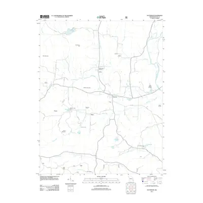
2011 Map of Patterson
USGS Topo · Published 2011About this map
Patterson sits at the heart of this Wayne County landscape, where the Saint Francis River flows along the eastern edge and numerous tributaries carve through the upland terrain. The map captures a high density of rural genealogy sites, including the Sparks Cemetery, English Cemetery, and Julian Cemetery, alongside smaller settlements like Damon, Rings, and Kyles. The drainage patterns of Logan Creek, Rings Creek, and Little Lake Creek define the local geography, with various small impoundments such as Little Hawaiis Lake and A O Shearrer Lake marking the modern development of the watershed. Notable landmarks like the Julian Lookout Tower on the southern heights and Neelys Mill near the town center reflect a mix of early 21st-century conservation infrastructure and historic local industry. Prominent summits including Daffron Mountain and Frenchman Hill rise above the winding network of county roads that link these isolated Ozark communities.
Find a feature on this map
62 named features on this map. Tap any name to fly to it.
Don’t see what you’re looking for? This feature index may not catch every label — zoom into the map to look around manually.
Map Details
Editions of this 2011 Patterson Map
This is the sole edition of this map. No revisions or reprints were ever made.
Other maps of this area

1926 · Des Arc
USGS Topo · 1:62,500

1929 · Des Arc
USGS Topo · 1:62,500

1930 · Coldwater
USGS Topo · 1:62,500

1932 · Piedmont
USGS Topo · 1:62,500

1934 · Greenville
USGS Topo · 1:62,500

1935 · Piedmont
USGS Topo · 1:62,500

1939 · Greenville
USGS Topo · 1:62,500

1949 · Rolla
USGS Topo · 1:250,000

1949 · Coldwater
USGS Topo · 1:62,500

1953 · Rolla
USGS Topo · 1:250,000