
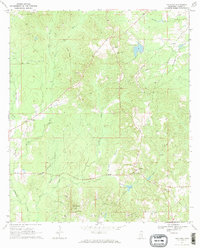
1970 Map of Paulding
USGS Topo · Published 1972About this map
Paulding and its surrounding countryside in Jasper County are defined by a complex network of waterways and early petroleum development in the late 1960s. The landscape is carved by Tallahala Creek, Goodwater Creek, and South Twistwood Creek, with numerous Oil Wells peppered across the terrain, indicating the industrial activity of the period. Local life centers on small rural communities like Missionary and Gridley, while the religious and social fabric is anchored by landmarks such as New Homer Ch and Spring Hill Ch. A notable recreational and geographic feature is Lake Claude Bennett, situated near the Jasper Lookout Tower. The presence of a Pumping Sta and various pipelines further illustrates the region's role in Mississippi's energy infrastructure during this era.
Find a feature on this map
27 named features on this map. Tap any name to fly to it.
Don’t see what you’re looking for? This feature index may not catch every label — zoom into the map to look around manually.
Map Details
Editions of this 1970 Paulding Map
2 editions found
Other maps of this area

1953 · Hattiesburg
USGS Topo · 1:250,000

1953 · Meridian
USGS Topo · 1:250,000

1957 · Meridian
USGS Topo · 1:250,000

1957 · Enterprise
USGS Topo · 1:62,500

1958 · Hattiesburg
USGS Topo · 1:250,000

1963 · Waldrup
USGS Topo · 1:24,000

1963 · Heidelberg
USGS Topo · 1:24,000

1964 · Lake Como
USGS Topo · 1:24,000

1965 · Meridian
USGS Topo · 1:250,000

1970 · Hero
USGS Topo · 1:24,000