
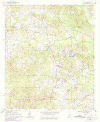
1970 Map of Hero
USGS Topo · Published 1972About this map
The boundary between Newton and Jasper Counties divides this 1970 landscape, centered on the community of Hero. This area of Mississippi is defined by a dense network of country churches and small rural hubs, including Garlandville and Twistwood. The topography is shaped by numerous watercourses, with Souinlovey Creek and Scotchenflipper Creek winding through the terrain. Evidence of local life and labor is visible in the scattered cemeteries, a Gravel Pit near Moss Hill, and family-named landmarks like McVay Creek. The map also captures the Hidden Valley Camp and various spiritual centers such as Wesley Chapel, New Concord Ch, and Mt Olive Ch, reflecting the social fabric of these communities during the late twentieth century. Fine red dashed lines throughout the map delineate field and fence lines interpreted from 1968 aerial photography, offering a detailed view of land use and property divisions of the era.
Find a feature on this map
25 named features on this map. Tap any name to fly to it.
Don’t see what you’re looking for? This feature index may not catch every label — zoom into the map to look around manually.
Map Details
Editions of this 1970 Hero Map
2 editions found
Other maps of this area

1953 · Meridian
USGS Topo · 1:250,000

1957 · Meridian
USGS Topo · 1:250,000

1957 · Chunky
USGS Topo · 1:62,500

1957 · Enterprise
USGS Topo · 1:62,500

1965 · Meridian
USGS Topo · 1:250,000

1966 · Hickory
USGS Topo · 1:24,000

1966 · Newton
USGS Topo · 1:24,000

1970 · Paulding
USGS Topo · 1:24,000
1970 · Montrose North
USGS Topo · 1:24,000
1970 · Montrose South
USGS Topo · 1:24,000