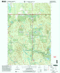
1999 Map of Paulding
USGS Topo · Published 2004About this map
The Middle Branch Ontonagon River carves through this northern Michigan landscape, defined by the extensive waterways and managed timberlands of the Ottawa National Forest. Small settlements such as Paulding and the rail-aligned Robbins reflect the area’s remote development, with Craigsmere situated near the headwaters of Redlight Creek. A sophisticated network of water management is evident in the Falls Levee and Bond Falls Flowage, where a Gaging Station and multiple boat access points indicate the importance of the river system for both utility and recreation. Local history is anchored at the Maple Grove Cem and the Townhall near Erickson Lake. The terrain transitions from the low-lying Sleepy Hollow to numerous scattered water bodies like Kennedy Lake and Amber Lake, many of which are connected by forest roads and historic tracks such as Amber Lake Avenue.
Find a feature on this map
34 named features on this map. Tap any name to fly to it.
Don’t see what you’re looking for? This feature index may not catch every label — zoom into the map to look around manually.
Map Details
Editions of this 1999 Paulding Map
This is the sole edition of this map. No revisions or reprints were ever made.
Other maps of this area

1949 · Rockland
USGS Topo · 1:62,500

1951 · Rockland
USGS Topo · 1:62,500

1952 · Watersmeet
USGS Topo · 1:62,500

1952 · Thayer
USGS Topo · 1:62,500

1956 · Matchwood
USGS Topo · 1:62,500

1958 · Iron River
USGS Topo · 1:250,000

1960 · Iron River
USGS Topo · 1:250,000

1961 · Iron River
USGS Topo · 1:250,000

1967 · Iron River
USGS Topo · 1:250,000

1979 · Ontonagon
USGS Topo · 1:100,000