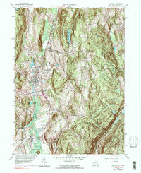
1958 Map of Pawling
USGS Topo · Published 1990About this map
Hammersly Ridge and West Mountain dominate the skyline of this Hudson Valley landscape, where the town of Pawling sits between the ridges and the extensive wetlands of the Great Swamp. The survey captures the area during a period of transition, showing the Penn Central rail line cutting through the valley and connecting local settlements like Patterson and Hurd Corners. The presence of the Trinity-Pawling Sch and the Meeting House on Quaker Hill highlights the established community institutions that have long defined this portion of the New York-Connecticut border. Water plays a central role in the topography here, with the East Branch Croton River and Swamp River draining the lowlands, while numerous small lakes like Quaker Lake and Green Mountain Lake are tucked into the upland folds of Dutchess County.
Find a feature on this map
56 named features on this map. Tap any name to fly to it.
Don’t see what you’re looking for? This feature index may not catch every label — zoom into the map to look around manually.
Map Details
Editions of this 1958 Pawling Map
4 editions found
Other maps of this area

1892 · Danbury
USGS Topo · 1:62,500

1892 · New Milford
USGS Topo · 1:62,500

1892 · Carmel
USGS Topo · 1:62,500

1893 · Carmel
USGS Topo · 1:62,500

1893 · New Milford
USGS Topo · 1:62,500

1893 · Clove
USGS Topo · 1:62,500

1894 · Clove
USGS Topo · 1:62,500

1894 · Carmel
USGS Topo · 1:62,500

1898 · Clove
USGS Topo · 1:62,500

1901 · Clove
USGS Topo · 1:62,500