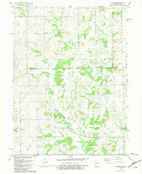
1981 Map of Pawnee
USGS Topo · Published 1981About this map
Big Creek and its West Fork define the agricultural landscape of this borderland region in the early 1980s. Straddling the Iowa Missouri state line, the area is divided into several townships including Riley, Fayette, and Hamilton. The settlement of Pawnee serves as a small local hub, complemented by a Community Center further north. This survey is particularly valuable for its preservation of family-named sites and rural landmarks, tracing established burial grounds such as Mt Zion Cem and Patrick Cem.
Find a feature on this map
22 named features on this map. Tap any name to fly to it.
Don’t see what you’re looking for? This feature index may not catch every label — zoom into the map to look around manually.
Map Details
Editions of this 1981 Pawnee Map
This is the sole edition of this map. No revisions or reprints were ever made.
Other maps of this area

1945 · Mount Ayr
USGS Topo · 1:62,500

1945 · Lamoni
USGS Topo · 1:62,500

1947 · Lamoni
USGS Topo · 1:62,500

1947 · Blythedale
USGS Topo · 1:62,500

1947 · Mount Ayr
USGS Topo · 1:62,500

1948 · Bethany
USGS Topo · 1:62,500

1954 · Centerville
USGS Topo · 1:250,000

1955 · Nebraska City
USGS Topo · 1:250,000

1957 · Nebraska City
USGS Topo · 1:250,000

1957 · Centerville
USGS Topo · 1:250,000