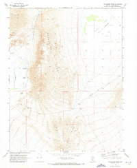
1970 Map of Paymaster Ridge
USGS Topo · Published 1973About this map
Paymaster Ridge dominates this central Nevada landscape, recorded here as it appeared in the late 1960s. The topography is defined by significant elevation changes and arid depressions, notably the broad Alkali Lake (Depression) and the sprawling Clayton Valley (Depression). Localized water sources like Pearl Hot Springs and Twin Springs were essential landmarks for travelers navigating this environment, which was primarily traversed via unpaved routes such as Salt Spring Road and Pearl Road. Numerous labels for Prospects and individual Prospect sites scattered along the slopes of Paymaster Canyon and the Weepah Hills suggest a history of mineral exploration throughout the Esmeralda County backcountry. The arrangement of these mining markers alongside faint tracks like Silver Peak Road provides insight into the logistical challenges of resource extraction in this high-desert terrain.
Find a feature on this map
17 named features on this map. Tap any name to fly to it.
Don’t see what you’re looking for? This feature index may not catch every label — zoom into the map to look around manually.
Map Details
Editions of this 1970 Paymaster Ridge Map
2 editions found
Other maps of this area

1898 · Silver Peak
USGS Topo · 1:125,000

1900 · Silver Peak
USGS Topo · 1:125,000

1908 · Lida
USGS Topo · 1:250,000

1913 · Lida
USGS Topo · 1:250,000

1945 · Goldfield
USGS Topo · 1:125,000

1954 · Goldfield
USGS Topo · 1:250,000

1955 · Goldfield
USGS Topo · 1:250,000

1958 · Goldfield
USGS Topo · 1:250,000

1962 · Goldfield
USGS Topo · 1:250,000

1963 · Silver Peak
USGS Topo · 1:62,500