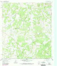
1963 Map of Payton
USGS Topo · Published 1987About this map
The community of Payton sits at the northern edge of this landscape, serving as a focal point for the surrounding Hill Country ranching and farming territory. This map documents the area during the early 1960s, prior to major modern development, showing the essential local infrastructure of the Payton Sch and the Payton Cem. The terrain is deeply carved by the Blanco River and the Little Blanco River, which define the local drainage patterns alongside numerous smaller seasonal waterways like Greens Branch and Kentucky Branch.
Find a feature on this map
25 named features on this map. Tap any name to fly to it.
Don’t see what you’re looking for? This feature index may not catch every label — zoom into the map to look around manually.
Map Details
Editions of this 1963 Payton Map
3 editions found
Other maps of this area

1887 · Blanco
USGS Topo · 1:125,000

1894 · Blanco
USGS Topo · 1:125,000

1920 · Smithsons Valley
USGS Topo · 1:62,500

1925 · Smithson Valley No. 1
USGS Topo · 1:48,000

1927 · Smithson Valley
USGS Topo · 1:62,500

1929 · Hunter
USGS Topo · 1:62,500

1929 · Smithson Valley
USGS Topo · 1:62,500

1940 · Smithson Valley
USGS Topo · 1:62,500

1954 · Llano
USGS Topo · 1:250,000

1954 · San Antonio
USGS Topo · 1:250,000