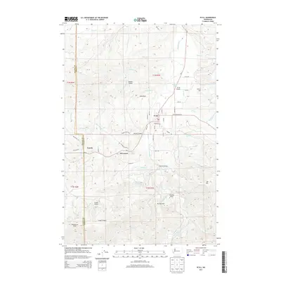
2013 Map of Pe Ell
USGS Topo · Published 2013About this map
Pe Ell serves as the primary hub in this southwestern Washington landscape, where the Chehalis River winds through a complex topography of canyons and ridges. Small settlements like McCormick and Walville are situated along the Wa-6 corridor and Rock Creek, reflecting a history tied to the regional timber and transport networks. The terrain is defined by dramatic elevation changes, from the heights of Huckleberry Ridge and Joy Mtn to the depths of Mullers Canyon. Local water resources are central to the area, evidenced by the Lester Creek Reservoir and numerous named tributaries like Jones Creek and Seven Creek. Significant local landmarks such as Jones Bluff and Charlies Hump rise above the river valley, while Pe Ell Prairie offers a rare break in the timbered slopes. This detailed 2013 survey documents the intersection of rural residential life and the heavy industrial presence of logging roads.
Find a feature on this map
67 named features on this map. Tap any name to fly to it.
Don’t see what you’re looking for? This feature index may not catch every label — zoom into the map to look around manually.
Map Details
Editions of this 2013 Pe Ell Map
This is the sole edition of this map. No revisions or reprints were ever made.
Other maps of this area

1941 · Walville
USGS Topo · 1:62,500

1941 · Meskill
USGS Topo · 1:62,500

1941 · Skamokawa
USGS Topo · 1:62,500

1953 · Hoquiam
USGS Topo · 1:250,000

1953 · Ryderwood
USGS Topo · 1:62,500

1953 · Skamokawa
USGS Topo · 1:62,500

1953 · Pe Ell
USGS Topo · 1:62,500

1953 · Adna
USGS Topo · 1:62,500

1957 · Hoquiam
USGS Topo · 1:250,000

1958 · Hoquiam
USGS Topo · 1:250,000