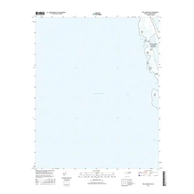
2016 Map of Pea Island OE W
USGS Topo · Published 2016About this map
Cape Hatteras National Seashore encompasses a dynamic barrier island landscape on this 2016 survey, where the shifting sands of the Outer Banks meet the Atlantic Ocean and Pamlico Sound. This specific portion of the coast, near the northern reach of the seashore, is characterized by a complex network of small islands and marshy points. Notable landforms such as Goat Island, Goose Island, and Douglas Island are separated by shallow reaches including Goat Island Bay and the narrow channel known as The Trench. The map documents the fragile geography of Pea Island Point and Terrapin Creek Point, reflecting the ongoing coastal processes that shape this environment. Infrastructure is minimal, limited primarily to the coastal corridor of Route 12, which provides the only terrestrial access through this protected maritime wilderness.
Find a feature on this map
18 named features on this map. Tap any name to fly to it.
Don’t see what you’re looking for? This feature index may not catch every label — zoom into the map to look around manually.
Map Details
Editions of this 2016 Pea Island OE W Map
This is the sole edition of this map. No revisions or reprints were ever made.
Other maps of this area

1943 · Roanoke Island
USGS Topo · 1:125,000

1953 · Wanchese
USGS Topo · 1:24,000

1953 · Stumpy Point
USGS Topo · 1:24,000

1955 · Wanchese
USGS Topo · 1:250,000

1957 · Manteo
USGS Topo · 1:250,000

1960 · Manteo
USGS Topo · 1:250,000

1985 · Manteo
USGS Topo · 1:100,000
2002 · Stumpy Point
USGS Topo · 1:24,000
2011 · Long Shoal Point OE E
USGS Topo · 1:24,000
2011 · Oregon Inlet
USGS Topo · 1:24,000