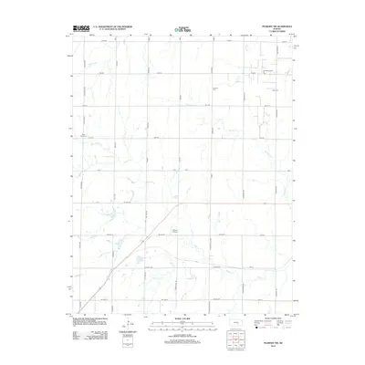
2012 Map of Peabody NW
USGS Topo · Published 2012About this map
Doyle Valley Cem and Dunkard Cem sit within the rural sections of Harvey County, marking a landscape defined by small family cemeteries and agricultural life. The terrain is crisscrossed by several winding watercourses, including Doyle Cr, Antelope Cr, and the W Br Whitewater Cr, which dictated early settlement patterns and the placement of country roads. The northeastern portion of the quadrangle shows the footprint of the Southwest Unger Oil Field, indicating the intersection of farming and energy extraction in this part of Kansas. A small private landing strip, Gilley's Airport, appears near the center of the sheet, while the rectilinear grid of roads like Indigo Rd and Mustang Rd provides a clear view of the modern land division following Section lines.
Find a feature on this map
39 named features on this map. Tap any name to fly to it.
Don’t see what you’re looking for? This feature index may not catch every label — zoom into the map to look around manually.
Map Details
Editions of this 2012 Peabody NW Map
This is the sole edition of this map. No revisions or reprints were ever made.
Other maps of this area

1889 · Newton
USGS Topo · 1:125,000

1894 · Newton
USGS Topo · 1:125,000

1955 · Hutchinson
USGS Topo · 1:250,000

1957 · Newton
USGS Topo · 1:24,000

1957 · Peabody NW
USGS Topo · 1:24,000

1957 · Peabody
USGS Topo · 1:24,000

1957 · Elbing
USGS Topo · 1:24,000

1959 · Hutchinson
USGS Topo · 1:250,000
1962 · Peabody SE
USGS Topo · 1:24,000

1965 · Goessel
USGS Topo · 1:24,000