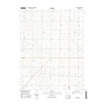
2015 Map of Peabody NW
USGS Topo · Published 2015About this map
Agricultural lands along the border of Marion and Harvey counties are defined by a network of sectional roads and meandering creek beds. Doyle Cr and its tributaries, including Antelope Cr and Spring Cr, carve through the landscape, influencing the placement of early settlements and rural infrastructure. Genealogists will find several notable burial sites preserved here, including the Doyle Valley Cem in the west and Catlin Cem to the east. The presence of the Dunkard Cem near Kanza Rd points to the area's heritage of German Baptist Brethren settlement. The survey illustrates the persistence of the Public Land Survey System, with township lines like t21s r2e and t22s r3e anchoring the grid of gravel and paved routes such as Goldenrod Rd and Mustang Rd.
Find a feature on this map
44 named features on this map. Tap any name to fly to it.
Don’t see what you’re looking for? This feature index may not catch every label — zoom into the map to look around manually.
Map Details
Editions of this 2015 Peabody NW Map
This is the sole edition of this map. No revisions or reprints were ever made.
Other maps of this area

1889 · Newton
USGS Topo · 1:125,000

1894 · Newton
USGS Topo · 1:125,000

1955 · Hutchinson
USGS Topo · 1:250,000

1957 · Newton
USGS Topo · 1:24,000

1957 · Peabody NW
USGS Topo · 1:24,000

1957 · Peabody
USGS Topo · 1:24,000

1957 · Elbing
USGS Topo · 1:24,000

1959 · Hutchinson
USGS Topo · 1:250,000
1962 · Peabody SE
USGS Topo · 1:24,000

1965 · Goessel
USGS Topo · 1:24,000