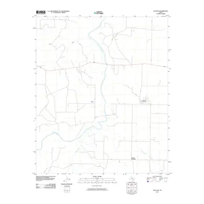
2010 Map of Peacock
USGS Topo · Published 2010About this map
Peacock and the surrounding Stonewall County ranch lands are defined by the winding course of the Salt Fork Brazos River, which cuts a deep path through this section of West Texas. The small settlement of Oriana lies near the riverbanks, supported by the Oriana Cemetery further north, serving as a quiet focal point for local family history. To the south, the landscape rises toward the prominent landmark of Double Mountain, while intermittent drainages like Stinking Creek and Carter Draw reveal the erosive power of the region's seasonal waters. The map illustrates a grid of rural routes, including FM 2211 and numerous county roads, that connect these isolated communities. This 2010 survey provides a high-resolution view of the local topography and land use patterns before significant modern changes, documenting the enduring footprint of these rural outposts.
Find a feature on this map
27 named features on this map. Tap any name to fly to it.
Don’t see what you’re looking for? This feature index may not catch every label — zoom into the map to look around manually.
Map Details
Editions of this 2010 Peacock Map
This is the sole edition of this map. No revisions or reprints were ever made.
Other maps of this area

1954 · Lubbock
USGS Topo · 1:250,000

1958 · Seven Diamond L Canyon
USGS Topo · 1:24,000

1958 · Lovers Resort
USGS Topo · 1:24,000

1958 · Jayton
USGS Topo · 1:24,000

1968 · Double Mountains
USGS Topo · 1:24,000
1968 · Coon Hollow
USGS Topo · 1:24,000

1968 · Peacock
USGS Topo · 1:24,000
1968 · Swenson
USGS Topo · 1:24,000
1969 · A B C Creek
USGS Topo · 1:24,000

1969 · Jayton South
USGS Topo · 1:24,000