
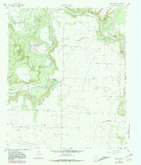
1958 Map of Lovers Resort
USGS Topo · Published 1959About this map
The Salt Fork Brazos River carves a winding path through this portion of Stonewall County, defining the wide Brazos Valley where petroleum exploration and rural community life intersected in the late 1950s. The landscape is dotted with numerous Oil Wells and a specific Oil Sludge Pit, highlighting the industrial footprint on the Texas plains. Social and civic life for local residents centered on landmarks like the Shinnery Lake Community Hall near Shinnery Lake, and the remote Lovers Resort situated along the river bends. Genealogists and local historians will find the Brazos Valley Cemetery a significant point of interest, while the presence of the Betta Bend Conglomerate Field indicates the unique geological character of the terrain where Salt Croton Creek joins the larger river system.
Find a feature on this map
12 named features on this map. Tap any name to fly to it.
Don’t see what you’re looking for? This feature index may not catch every label — zoom into the map to look around manually.
Map Details
Editions of this 1958 Lovers Resort Map
2 editions found
Other maps of this area

1931 · Aspermont
USGS Topo · 1:62,500

1954 · Lubbock
USGS Topo · 1:250,000

1958 · Southerland Canyon
USGS Topo · 1:24,000

1958 · Seven Diamond L Canyon
USGS Topo · 1:24,000

1959 · Bob Creek
USGS Topo · 1:24,000

1967 · Kiowa Peak NW
USGS Topo · 1:24,000

1967 · Kiowa Peak SW
USGS Topo · 1:24,000
1968 · Aspermont
USGS Topo · 1:24,000

1968 · Peacock
USGS Topo · 1:24,000
1968 · Swenson
USGS Topo · 1:24,000