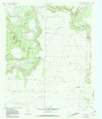
1958 Map of Lovers Resort
USGS Topo · Published 1981About this map
The Salt Fork Brazos River snakes through this Texas landscape, carving the prominent Brazos Valley and meeting with Salt Croton Creek in the north. This 1958 survey, updated with 1978 photogrammetric data, documents a rural expanse defined by scattered petroleum and resource extraction, including the Berta Bend Conglomerate Field and various sludge and gravel pits. Settlement is sparse, anchored by the Shinnery Lake Community Hall and the Brazos Valley Cemetery. A curious local landmark, Lovers Resort, sits tucked into a bend of the river, serviced by a nearby Landing Strip. The map illustrates the transition from river-bottom vegetation to the open flats characteristic of Stonewall County, revealing the late-century infrastructure of the regional oil and gas industry.
Find a feature on this map
10 named features on this map. Tap any name to fly to it.
Don’t see what you’re looking for? This feature index may not catch every label — zoom into the map to look around manually.
Map Details
Editions of this 1958 Lovers Resort Map
2 editions found
Other maps of this area

1931 · Aspermont
USGS Topo · 1:62,500

1954 · Lubbock
USGS Topo · 1:250,000

1958 · Southerland Canyon
USGS Topo · 1:24,000

1958 · Seven Diamond L Canyon
USGS Topo · 1:24,000

1958 · Lovers Resort
USGS Topo · 1:24,000

1959 · Bob Creek
USGS Topo · 1:24,000

1967 · Kiowa Peak NW
USGS Topo · 1:24,000

1967 · Kiowa Peak SW
USGS Topo · 1:24,000
1968 · Aspermont
USGS Topo · 1:24,000

1968 · Peacock
USGS Topo · 1:24,000