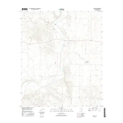
2016 Map of Peacock
USGS Topo · Published 2016About this map
Peacock stands as the primary settlement in this corner of Stonewall County, where the landscape is defined by the winding course of the Salt Fork Brazos River. The terrain is characterized by deep incisions like Carter Draw and several seasonal watercourses including the aptly named Stinking Cr. This area maintains a sparse, rural character typical of the Texas Rolling Plains, with life oriented around a grid of farm-to-market roads and county routes. Genealogists and local historians will find the Oriana Cem west of the river, a quiet marker of the community's early residents and the vanished local centers that once dotted the plains. The map illustrates the 21st-century road network, showing how FM 2211 and several named county roads like Co RD 419 connect these isolated landmarks across the undulating ranch land.
Find a feature on this map
29 named features on this map. Tap any name to fly to it.
Don’t see what you’re looking for? This feature index may not catch every label — zoom into the map to look around manually.
Map Details
Editions of this 2016 Peacock Map
This is the sole edition of this map. No revisions or reprints were ever made.
Other maps of this area

1954 · Lubbock
USGS Topo · 1:250,000

1958 · Seven Diamond L Canyon
USGS Topo · 1:24,000

1958 · Lovers Resort
USGS Topo · 1:24,000

1958 · Jayton
USGS Topo · 1:24,000

1968 · Double Mountains
USGS Topo · 1:24,000
1968 · Coon Hollow
USGS Topo · 1:24,000

1968 · Peacock
USGS Topo · 1:24,000
1968 · Swenson
USGS Topo · 1:24,000
1969 · A B C Creek
USGS Topo · 1:24,000

1969 · Jayton South
USGS Topo · 1:24,000