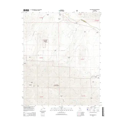
2015 Map of Peak Mountain
USGS Topo · Published 2015About this map
McPherson Peak and Peak Mtn dominate the high ridges of the Sierra Madre Mountains in this 2015 study of the borderlands between Santa Barbara and San Luis Obispo counties. The northern portion of the map covers the Cuyama Valley, where the Cuyama River winds through the flats alongside Wasioja Rd. Much of the southern terrain is protected within the Los Padres National Forest, a landscape defined by deep drainages like Wellman Canyon and Stovall Canyon. This modern digital topographic survey illustrates the remote water sources vital to the region, identifying scattered points such as Hog Pen Spring, Johnston Spring, and Buck Opening Spring. The map traces the winding course of Sierra Madre Rd as it follows the highest ridgelines, providing a clear view of the complex canyons that drop away from the peaks.
Find a feature on this map
44 named features on this map. Tap any name to fly to it.
Don’t see what you’re looking for? This feature index may not catch every label — zoom into the map to look around manually.
Map Details
Editions of this 2015 Peak Mountain Map
This is the sole edition of this map. No revisions or reprints were ever made.
Other maps of this area

1902 · Santa Ynez
USGS Topo · 1:125,000

1905 · Santa Ynez
USGS Topo · 1:125,000

1912 · McKittrick
USGS Topo · 1:125,000

1941 · Caliente Mountain
USGS Topo · 1:62,500

1941 · McPherson Peak
USGS Topo · 1:62,500

1942 · Caliente Mtn
USGS Topo · 1:62,500

1943 · McPherson Peak
USGS Topo · 1:62,500

1943 · Caliente Mtn.
USGS Topo · 1:62,500

1943 · Cuyama Ranch
USGS Topo · 1:31,680
1944 · Salisbury Potrero
USGS Topo · 1:31,680