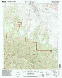
1995 Map of Peak Mountain
USGS Topo · Published 2000About this map
Cuyama Grant (Heirs of Cesario Lataillade) dominates the northern landscape of this mid-1990s survey, illustrating the persistence of historical land divisions in the high country of Santa Barbara County. The terrain shifts dramatically from the Cuyama Valley and the banks of the Cuyama River into the steep ridges of the Sierra Madre Mountains. This area is a network of springs and canyons, where vital water sources like Heath Spring and Richardson Spring supported early ranching efforts at the Caliente Ranch.
Find a feature on this map
40 named features on this map. Tap any name to fly to it.
Don’t see what you’re looking for? This feature index may not catch every label — zoom into the map to look around manually.
Map Details
Editions of this 1995 Peak Mountain Map
This is the sole edition of this map. No revisions or reprints were ever made.
Other maps of this area

1902 · Santa Ynez
USGS Topo · 1:125,000

1905 · Santa Ynez
USGS Topo · 1:125,000

1912 · McKittrick
USGS Topo · 1:125,000

1941 · Caliente Mountain
USGS Topo · 1:62,500

1941 · McPherson Peak
USGS Topo · 1:62,500

1942 · Caliente Mtn
USGS Topo · 1:62,500

1943 · McPherson Peak
USGS Topo · 1:62,500

1943 · Caliente Mtn.
USGS Topo · 1:62,500

1943 · Cuyama Ranch
USGS Topo · 1:31,680
1944 · Salisbury Potrero
USGS Topo · 1:31,680